Carlton Hill Multiple Use Area
Links
Google Maps Coordinates to Parking – Note, come up from the south to avoid the bumpy Bank St Rd
Stats
Ride or Drive – Ride Only
Trail Level – Advanced- steep hills, narrow paths, many creek bed crossings
Parking – Moderate – Will need to back into a space to allow room for others
Distance – 9 miles of trails – Get Printable Map Here
Footing – Fields, packed dirt, some gravel, roots, rocks, water crossings
Challenges – Challenging and fun trails, think safety first, ride with a friend if possible and stay on the trails! Recommend to condition you and your horse before going here.
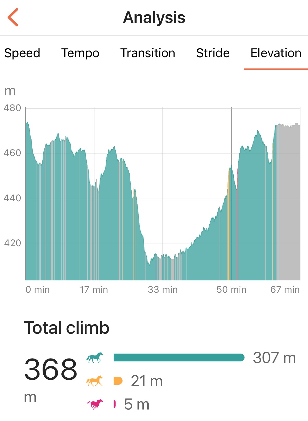
Elevation Graph:
Transcript
Rochester Trail Riders – Challenge 3 – Carlton Hill
Intro
Carlton Hill Multiple Use Area is 2,500 acres of DEC Managed properties that once boasted over 50 miles of trails and equestrian camping. Today horse trails are down to 9 miles and there are still 2 approved camping areas but not horse specific.
Maps for this park are nonexistent but were once plentiful. I have a feeling this is being done on purpose to lower the demand on the park. Those that ride here are amazing stewards and I got to meet several of them on my visit. I learned horses were almost entirely banded from the park a few years ago due to overuse and poor trail and trailer etiquette. Be conscious of weather conditions, and how your visit will impact the health of the trail and community areas.
Setting
Carlton Hill is located near Dale, NY in Wyoming County and is managed by the DEC Region 9 Headquarters in Allegany. There are 3 main parking areas and but the best one is middle Bank St Rd. The DEC is serious about staying on marked horse trails but don’t provide a usable map. Good news is, I’ve got one for you! You’ll be able to find it on the RTR website linked form the show notes.
Expect narrow, rough herd path trails, with overgrowth and blow down, over very challenging terrain. Big elevation gains, extensive creek bed crossings, and large rocks. The trails remind me a LOT of the ones I rode as an Adirondack trail guide. Not a trail for novice riders, horses, or the unfit. Trees are clearly marked with an abundance of signage and painted blazes showing you the way.
Parking area feels small, so be mindful of how you maneuver your rig, and make sure others can park while you’re out on the trail. It’s mostly grass covered gravel and is bordered by large limestone rocks. Which make for great mounting blocks.
Prep
I chose to ride this park slightly on a whim. I wanted to round out my first 3 challenges covering 1 greenway, 1 county park and 1 state park. I went with the furthest park from me, Charlton Hill, a 40 min trip according to my GPS. Since this was an unknown trail system, I opted to ride not drive. With “hill” in the name, I assumed I’d encounter elevation climbs. I went with lightweight tack and cleaned up my Duette Companion endurance saddle.
Being an English saddle meant no jeans for me. YES! I get to do what English folks do best. Matchy matchy color coordinate an outfit. I failed. But on purpose. I had planned to ride with a friend, the timing wasn’t right though as she was volunteering for a horse show later in the day. Knowing I was going to ride a new trail, with no map and by myself, my outfit choice went from cute and matchy to shield your eyes insane. Purple marble tights and hunter blaze orange shirt, would allow me to be easily be found should I become separated from my horse. The riding tights I chose have a phone pocket which also keeps the phone on me and not my horse. Yes, I always plan my adventures considering worst case scenario. Add to it my Apple watch fall detection and My EquiLab App with Safety Tracking enabled I’m prepared to be yeeted into orbit and still be tracked.
My last over thinking prep was my Camelbak day pack. Which carries not only water but my first-aid kit for human and horse along with a lead rope and hoof pick. Since I’m carrying it and not on the saddle it too stays with me for those ill-timed gravity checks. An added bonus, the water bladder acts as a cushion upon impact. Overkill? Probably, but my time as a guide has me over prepare vs under and many times, I’ve been thankful I have.
Journey
The goal for the day was to start out at 6am, therefore I could choose to either stay and enjoy the park longer, or come home by 10am, and have time to do work on the farm. Naturally I screwed around until 9am and didn’t leave until almost 10am. Oh well, best laid plans and all.
I picked a parking lot at random and set my GPS. The trip felt shorter than I expected. When I got close, I passed the “Motorized Access Program for People with Disabilities” lot and noticed a trailer in it. The lot had a pull through, so I made my way in and was greeted by a gentleman.
His name, Larry and he was a wealth of information! He informed me my best place to start as a first timer was the Middle Bank Street Rd Lot, which I ironically had randomly picked on my GPS. However, he said the way the GPS was taking me was awful and bumpy and to back track to Kingsley to Moose Roads and come up from the south to Bank St.
The DEC used to have pamphlet bins at each lot with maps but they were either missing all together or empty. No bother, the trails he said are well marked. He too was planning a ride with friends from the Middle lot after he date with a down tree. Maybe he’d see me out there on the trails later.
I pulled through and headed back to Kingsley, promptly missing the turn, and drove all the way back to East Bethany Rd, to Webster, then to Kingsley, and Moose. Seemed like it was out of the way, but after getting on Bank St., I was thankful for the recommendation. The road is rough! But, the path from the south is short, and got to the lot fast.
I pulled in to find another weekender trailer there with its occupants already on the trail, along with another car. I assumed this guy was at a campsite for the weekend. Either that, or he took his hydration very seriously as he shouldered a case of water and casually disappeared into the woods.
I backed into a shady spot and unloaded Pete. After talking to Larry, my preparations for a challenging ride would be validated. I chose to cross the road because I saw a friendly sign that said, “horse trail” and made my way through fresh cut field.
Though the trail itself is just a herd path, the signs and blazes made it very easy to follow. It quickly went from comfy trail to immediate challenge the second we entered the woods. Pete and I stared down a steep narrow path. I swear I heard Pete say, lady you’re nuts, and stopped dead. With slight coaxing, he carefully made his way down and shortly after, came our first real refusal.
Pete, is my dressage and carriage horse. Yes, we’ve done “trails,” but nicely groomed, with wide bridges, and pleasant footing. Today would test every part of him, physically and mentally.
First challenge, wooden foot bridge over a dry drainage bed complete with large rocks at the bottom. It was clear with hoof prints that horses did not cross the bridge but made their way through the ditch. Nope, said Pete. Hell No. Not Happening, wanna go home. It felt like forever of me constantly readjusting him to face the path then stop and wait for him to inspect it. Eventually he realized all answers to his tantrums pointed him right back to where he didn’t want to be and the only right answer was walk through. We made it! Golly, 100 yards in and it took us 15 min, this is going to be a long ride.
The path was all wooded from this point forward and meandered through the trees. Several smaller dips through dry drainage beds that he insisted on stopping and inspecting every time, followed by a few steeper down slopes but nothing in comparison to what was to come.
At one point we found ourselves high up on a ridge with a massive gully to my right. I kept thinking, no way I want to be at the bottom of that, nope. Not happening. The trail slowly switch backed a few times before…. The big drop.
At this point I needed Pete to stop, because I mentally needed to prepare. Pro: The footing had been dry, no slick mud and the leaf cover wasn’t an issue to cause more slippage. So far Pete had been sure footed and conscious of all 4 legs and their placement. I made the decision to at least give it a try.
Pete attempted a side pass mauver down, but I quickly straightened him out. Glad I put a crupper on the saddle today! He cautiously picked his way down and we soon found ourselves at the bottom of the gully I said I didn’t want to be at the bottom of.
To this point, I’ve been able to remain mounted for each challenge but crossing the creek bed itself required motivation from the ground. Pete was having no part of obstacle, and did several rears and spins to try to get out of going into the bed. Even when I got off to lead him down, he still hesitated and resisted.
My method of training an obstacle is just stand there. Making the path forward the only answer. Pete eventually realized his protests weren’t going to work and cautiously picked his path down into the creek bed, around large rocks and pools of water. The creek itself wasn’t running at the time of our crossing, thankfully I remained dry!
On the other side, I looked for a spot to mount up and guess what, the trail made its way BACK across the creek bed again. I remained the ground and helped Pete cross it a second time before getting back on.
The trail did this again several more times and each time Pete let me stay on and made his way across. Good boy!
Eventually, the trail felt like it was leaving the creek area and seemingly looping its way back. With no map, I was clueless if the trail was a loop, or if doubling back the way we came was a better plan. Thankfully I had started my EquiLab App which tracks our path via GPS. A quick swipe and yes, we were in fact making our way back. I made a mental note to look for familiar landmarks.
Then came the fun part, with all that decent meant we had to climb back out and before us a whole lotta up. I’m a walking trail rider, my body ached already from the difficulty of this trail. Knowing that a gallop up is easiest on a horse, I prepared myself for Pete showing me his true black stallion strength.
I grabbed fistfuls of mane and leaned into my 2-point as he started off at a comfortable trot and soon launched into a powerful push up the hill. Thankful for the mane handle, I tried to remain as balanced as I could as each stride thrust us closer to the top.
At one point he attempted to take a spur off to the left, but I corrected him to keep going up. Idiot, horses know better than you. When we reached the “top,” my gut said, you’ve been here before. Sure enough, after checking EquiLab I had missed the turn off, which so happened to be the very spot Pete wanted to turn. Smart boy, and I gave him some love.
Our ride back to the trail head was uneventful and the scary ditch/bridge crossing he balked at the first time was not an issue at all back through. Upon returning to the trailers, I met up with Larry and his friends as they prepped to head out. Introductions made, one of the riders, Christine, informed me she had submitted the trail map to Rochester Trail Riders some time ago and was surprised I didn’t have it. Why I had not checked my OWN directory for a map before I left? We said our goodbyes as they started out and I loaded up for home.
Returning home, I logged on and sure enough, the map is plainly linked under Trail Maps on the website. Palm to forehead move there, oh well, next time!
Conclusion
Carlton Hill – #3 in the books. Kind of.
Distance: 4.0km (2.5 miles) Need to go back!
Time: 1hr
Average Speed: 3.6km/h
Top Speed: 13.0km/h
Elevation Gain: 368m (1,207ft) Check the episode page or Youtube video to see a graph of the terrain.
Carlton Hill Rating:
Parking: Small but functional 3 Horse Hooves: There were 4 of us in rather large Rigs and room for more. You will need to know how to back up into your spot to make sure others have room.
Maps/Signage: 3 Hooves – DEC website is terrible and useless. The Map Christine gave me years ago is accurate! Be sure to download or print it out before you go! For reference I was on Trail #5 on the map. The signage on the trail itself was very clear!
Difficulty: 4 Hooves! I can only speak for Trail 5 and it was insanely awesome. If by awesome you mean you checked your sanity at the trailer. I’m told if I had stayed on the same side of the road, it wouldn’t have been so crazy. Best to be prepared when riding here.
Maintenance: 2 hooves. The state keeps the parking areas and fields mowed. Trails are kept up by DEC Stewards and are herd path wide. Be a good trail guardian and stick to marked areas ONLY and avoid the park in poor footing conditions to prevent mud ruts. This is a wildlife managed area, your goal should be to leave minimal impact on the land.
In Conclusion I REALLY enjoyed my time at this park and will be back for sure with more time to explore. If you visit on horseback, be sure to respect the trail conditions, signage and clean up common areas. The state drastically cut down horse accessibility due to complaints and inconsiderate visitors. If you want this park to remain open to horse traffic, educate yourself on “leave no trace” methods of trail stewardship. Understand that the DEC is attempting to bring this cluster of properties back to native habitats and heavy traffic of any sort will close off access even more. It is a privilege to be able to ride and that privilege can be taken away with the actions of a few bad apples.
That wraps up today’s show, until next time. Respect the trail, wear a helmet and clean up after your horse at the trailer site. Happy Trails!
Discover more from Rochester Trail Riders
Subscribe to get the latest posts sent to your email.